Datei:Map Roanoke & Jamestown 1584-1632.jpg
Zur Navigation springen
Zur Suche springen

Größe dieser Vorschau: 460 × 600 Pixel. Weitere Auflösungen: 184 × 240 Pixel | 690 × 900 Pixel.
Originaldatei (690 × 900 Pixel, Dateigröße: 156 KB, MIME-Typ: image/jpeg)
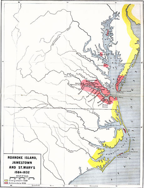
Roanoke Island, Jamestown, and St. Mary's. A map of the Chesapeake Bay and Pamlico Sound area showing the initial Virginia Colony established by Sir Walter Raleigh and Queen Elizabeth I in 1584 through the European settlements established by 1634, including Roanoke Island, Jamestown (1607), and St. Mary's, Maryland (1632). The map is color–coded to show the coastal areas granted in 1609, and the areas settled by 1632. Place Names: Early America 1400-1800, Roanoke, St. Mary's, Jamestown, Colonial America. Maps ETC is a part of the Educational Technology Clearinghouse [1]
Dateiversionen
Klicke auf einen Zeitpunkt, um diese Version zu laden.
| Version vom | Vorschaubild | Maße | Benutzer | Kommentar | |
|---|---|---|---|---|---|
| aktuell | 16:19, 23. Jun. 2017 | | 690 × 900 (156 KB) | Oteriwutaban (Diskussion | Beiträge) | Roanoke Island, Jamestown, and St. Mary's. A map of the Chesapeake Bay and Pamlico Sound area showing the initial Virginia Colony established by Sir Walter Raleigh and Queen Elizabeth I in 1584 through the European settlements established by 1634, incl… |
- Du kannst diese Datei nicht überschreiben.
Dateiverwendung
Die folgenden 5 Seiten verwenden diese Datei: