Datei:Map Britannia 49-84.jpg
Zur Navigation springen
Zur Suche springen

Größe dieser Vorschau: 321 × 600 Pixel. Weitere Auflösungen: 128 × 240 Pixel | 1.024 × 1.914 Pixel.
Originaldatei (1.024 × 1.914 Pixel, Dateigröße: 448 KB, MIME-Typ: image/jpeg)
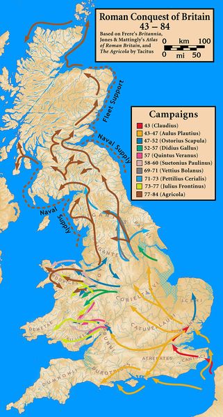
Di my work - Based on Frere's Britannia, Jones' & Mattingly's Atlas of Roman Britain, and The Agricola by Tacitus — sources are cited in the image legendThe topographical map is from a sub-region of File:Uk topo en.jpg, with the copyright notice Vorlage:Bild-GFDL-GMT and original date of 7 July 2006, copy made in 2008, with the annotations removed by myself., CC BY-SA 3.0, https://commons.wikimedia.org/w/index.php?curid=11357164
Dateiversionen
Klicke auf einen Zeitpunkt, um diese Version zu laden.
| Version vom | Vorschaubild | Maße | Benutzer | Kommentar | |
|---|---|---|---|---|---|
| aktuell | 18:37, 27. Jul. 2017 | | 1.024 × 1.914 (448 KB) | Oteriwutaban (Diskussion | Beiträge) | Di my work - Based on Frere's Britannia, Jones' & Mattingly's Atlas of Roman Britain, and The Agricola by Tacitus — sources are cited in the image legendThe topographical map is from a sub-region of File:Uk topo en.jpg, with the copyright notice {{Bi… |
- Du kannst diese Datei nicht überschreiben.
Dateiverwendung
Keine Seiten verwenden diese Datei.